Friday, December 2, 2016

The IAT's Big Loop:
How Did That Happen?

by Drew Hanson

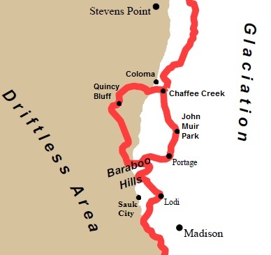
One of the common questions people ask about the Ice Age Trail is, "Why does it have a big loop in the middle?" Sometimes called the doughnut or inaccurately called the bifurcation, the big loop occupies a special chapter in the Ice Age Trail story.

Most of the general route of the Ice Age Trail is due to the plan of Ray Zillmer. He envisioned a long distance hiking trail following the interlobate ridges of the Kettle Moraine in eastern Wisconsin and the terminal moraine west to the border with Minnesota. Without Ray Zillmer, there would be no Ice Age Trail. But once Zillmer died in 1960, the Ice Age Trail almost died with him. More than 10 years passed before Congressman Henry Reuss stepped up to become the Trail’s greatest champion.

For the next three decades, Congressman Reuss was a major influence on most things Ice Age Trail. The full body of his Ice Age Trail accomplishments is far beyond the scope of this article. While the big loop is something he did not intend to create and something he at times worked against in favor of his preferred eastern leg, more than any single person we can thank Congressman Reuss for the existence of the big loop.

the Big Loop near the middle of the Ice Age Trail

During the years following Ray Zillmer’s untimely death, Ice Age Trail leaders increasingly realized that one of the weaknesses of Zillmer’s planned route was that it was not really possible to tell the story of continental glaciation if the Trail’s route adhered rigidly to the interlobate and terminal moraines, not to mention the fact that it would lack variety for anyone walking more than a short segment. Having the Ice Age Trail weave other types of landforms not found on a terminal moraine into the route would make for a better trail. Worth noting is the fact that neither leg of the big loop follows the terminal moraine.

One of Congressman Reuss’s many Ice Age Trail accomplishments was the book, On the Trail of the Ice Age, which he authored through three editions. Initially published in January, 1976 it was the first guidebook on the Ice Age Trail and it included the first set of maps and detailed description of the entire thousand mile route. In the doughnut area, the 1976 edition shows the Trail entirely as a single route of connecting roads between Sauk City and Coloma, passing through the city of Portage. The route skirts the edge of John Muir Park but remarkably misses the Baraboo Hills and Devils Lake Park entirely. The book gives no hint of the western route shown two years earlier on the official Ice Age Park and Trail Foundation brochure of 1974.

Ice Age Trail map from 1974

A major milestone in the history of the Ice Age Trail was the 1980 passage of the Ice Age Trail Act by Congress and signed by the President the same year. Although many people advocated for its designation as a National Scenic Trail, no one was more important to this effort than Congressman Reuss. The law even states that the Trail will be, “generally following the route described in ‘On the Trail of the Ice Age...’ by Henry S. Reuss, Member of Congress, dated 1980.” The route shown in the 1980 edition is the eastern leg — none of the western leg.

As required by the National Trails System Act, the National Park Service completed the Ice Age National Scenic Trail Comprehensive Plan for Management and Use in 1983. The route shown on maps in the plan roughly follows the eastern leg of the big loop but a note on one map states, “The Ice Age Trail Council is working on a rerouting of the trail from Devils Lake to Greenwood Wildlife Area. The rerouting would take the trail west into the Glacial Lake Wisconsin area...” (i.e., the western leg of what later became the big loop).

Also required by the National Trails System Act was appointment of an Advisory Council to assist the National Park Service “with respect to matters relating to the trail, including the selection of rights-of-way.” Appointed by the U.S. Secretary of the Interior, the Advisory Council was comprised of a dozen members including former Wisconsin Governor Warren Knowles, prominent citizens and active Ice Age Trail supporters. Given the conflicting ideas, the Advisory Council was not surprisingly asked to weigh in on the route through the doughnut area. In mid-1984 the Advisory Council approved the western route “to take the trail into the glacial Lake Wisconsin area” as the official route for the Ice Age Trail. But leaders from the city of Portage felt left out of the decision and Congressman Reuss remained unwilling to let go of his preferred route.

1976 map from On the Trail of the Ice Age

In a January 9, 1986 letter from Ice Age Park and Trail Foundation (later renamed the Ice Age Trail Alliance) President John Zillmer (Ray’s son) to Congressman Henry Reuss, John Zillmer addressed the Congressman’s efforts. At the time, Congressman Reuss also sat on the board of directors of the Ice Age Park and Trail Foundation. Referring to the route through the city of Portage, John Zillmer wrote, “this route has repeatedly been rejected by the Ice Age Park and Trail Foundation in spite of great pressure by you to approve it. As a matter of fact, you have been the only director to support this route. Your planned route was unanimously rejected by the Ice Age National Scenic Trail Advisory Council. It has been rejected by the Ice Age Trail Council. It has been rejected by the National Park Service. It has been rejected by the Wisconsin Department of Natural Resources... You have contributed so very much to what progress has been made. Why in the world are you now undermining all that you have worked so hard to accomplish?”

There was a lot of back and forth during those years about whether to make either the eastern or western legs the official route of the Ice Age Trail and designate the other one a National Side/Connecting Trail.

an Ice Age Trail map from 1986*

At one point Congressman Reuss resigned in protest from the board of directors of the Ice Age Park and Trail Foundation only to rejoin a few months later. The issue remained a source of unrest. Some maps of this era showed the eastern route through Portage while others showed the western route into the Driftless Area and Glacial Lake Wisconsin, depending on who created the map.

At last, an official effort to put the questions to bed reached fruition in early 1987. Letters were exchanged between Congressman Bruce Vento, Chairman of the Subcommittee on National Parks and Public Lands, and William Penn Mott Jr., National Park Service Director, that outlined what Congressman Vento called “a reasonable solution” of making the two legs of the big loop both part of the official route of the Ice Age National Scenic Trail. Thus the big loop was born out of compromise.

Still, in the 1990 edition of On the Trail of the Ice Age, Congressman Reuss showed none of the western leg of the big loop on any maps but he did include a one-paragraph description of its general route.

In 1999 the Partnership for the National Trail System held its annual conference at Lake Tahoe. Afterward a few of us accepted an invitation from Congressman Reuss to meet at his retirement home in Belvedere, CA. He and his wife were generous and delightful hosts. The elderly statesman had a few Ice Age Trail business items he wanted to impress upon us. One of these was the big loop. As he had done with me once before during a telephone call, at his dining room table he asked that we remove the western leg of the big loop from all maps. Having not lost his powers of persuasion, he made a strong case. But one of my companions that day was a long-time Ice Age Trail board member who provided an equally compelling counter argument. The retired Congressman elegantly shifted the discussion to his next topic.

Questions about the big loop still arise from time to time. Aspiring Thousand Milers sometimes ask if one must hike both legs of the big loop to be considered a Thousand Miler. The answer is “no.” In this case, half a doughnut is sufficient.

To some, the big loop remains a quirk in the Ice Age Trail. Others embrace it as part of what makes the Trail unique and wonderful.


------------------------------------------

* 1986 map appeared in Wisconsin's Foundations: A Review of the State's Geology and Its Influence on Geography and Human Activity, by Gwen Schultz, University of Wisconsin Press, 1986.


A version of this article first appeared in the Summer, 2016 edition of Mammoth Tales, a quarterly publication of the Ice Age Trail Alliance.


Wednesday, October 19, 2016

Proposed Yellow River Hemlock Esker National Monument

As wild places around the country are bestowed the protection of national monument status, it is time this attention and safeguarding be given to deserving areas along the Ice Age Trail. One such special place is located in the Chequamegon-Nicolet National Forest, in Taylor County, Wisconsin.

The proposed Yellow River Hemlock Esker National Monument is a magical place, centered around the prominent Hemlock Esker. This esker was created during the Ice Age by a river flowing at the base of a vast continental ice sheet. Imagine how huge the glacier must have been to have a river flowing inside at its base that deposited a miles-long sinuous ridge, what geologists today call an esker. The eastern and southern flanks of the esker, drained by sections of the wild Yellow River and some of its tributaries, are also part of the proposed monument.


Natural communities within the proposed monument include extensive tracts of mature hemlock-hardwood forest, areas of rich maple-basswood forest, open meadow in the upper reaches of Sailor Creek, several stands of lowland conifer dominated by white cedar and black ash and several headwater, morainal stream segments canopied with long lived species. The hemlock-hardwood forest is the dominant forest type occurring on hummocky end moraine and esker topography. Common associates include yellow birch, sugar maple and red maple. White ash, red oak, white spruce and super-canopy white pine are also present. Northern white cedar is frequently found on slopes bordering wetlands and in some ground moraine areas. Frequent snags and coarse woody debris contribute to the old-growth structure. An open shrub layer is dominated by hazelnut and gooseberry. Ground flora includes sweet cicely, intermediate wood fern, common oak fern and rough-leaved rice grass. The lowland coniferous forest forms a closed canopy white cedar forest in some areas. Black ash, red maple, yellow birch, hemlock and balsam fir are common associates. The ground layer is lush and diverse featuring such species as cinnamon fern, sensitive fern, one-sided shin-leaf, dwarf red raspberry, bunchberry and bryophytes. The understory is dense and consists of mountain maple, speckled alder and common winterberry. Bog forests of tamarack and black spruce with red maple, paper birch, yellow birch and white pine are present. Northern sedge meadows are common along Sailor Creek, especially where beaver have flooded the hardwood swamps. Both the northern goshawk (Accipiter gentilis) and red-shouldered hawk (Buteo lineatus) are documented breeding birds. Common resident birds include winter wren, hermit thrush, red-eyed vireo, ovenbird, blackburnian warbler and black-throated green warbler.

As national monuments go, the proposed Yellow River Hemlock Esker National Monument would be a small one, only about 8,000 acres. But what it lacks in size, it more than makes up for in significance. It includes most of the Ice Age Semi-Primitive Area, most of Lost Lake Esker State Natural Area and one of the wildest segments of the entire thousand-mile Ice Age National Scenic Trail. Note that contour maps of this area are in error and omit most of Hemlock Esker.


The proposed monument is administered by the Secretary of Agriculture, U.S. Forest Service, Chequamegon-Nicolet National Forest. National monument designation is needed to at last resolve long-term management issues. First, authorized and unauthorized motorized use is occurring within this geologically and recreationally unique area where the highest and best use is primitive, pedestrian recreational uses such as hiking, fishing, snowshoeing, birding and non-motorized hunting of non-predator species. Second, although timber harvest in parts of this area is currently limited, it should be permanently further restricted in the larger area encompassed by the proposed monument. This would allow additional old growth characteristics to develop that support wildlife species who depend on old growth conditions and enhance primitive, pedestrian recreation. Finally, existing modest protections for the Ice Age Trail and Semi-Primitive Area are temporary, based only on a management plan that is regularly re-written and open to interpretation. Negotiations over how this unique area needs to be managed should be put to rest instead of being re-hashed every decade or two. Local tourism would benefit by having such a unique and permanently protected national monument as more people would travel greater distances to experience such a wild and special place.

Some of the countless articles showing the economic benefits of national monuments are:
http://headwaterseconomics.org/public-lands/protected-lands/national-monuments/
http://www.nationalparkstraveler.com/2010/03/there-economic-value-national-monument-your-backyard5531
http://conservationlands.org/wp-content/uploads/2015/07/BSM-EIA-Final-Report-2015.pdf
http://www.forbes.com/sites/timworstall/2016/09/16/economics-says-yay-to-the-atlantic-ocean-marine-national-monument/#4e3fa67c3ed1

The proposed Yellow River Hemlock Esker National Monument would be good for the public, good for wildlife and good for the local economy.


Monday, April 18, 2016

Wisconsin Hiking Pioneers

by Drew Hanson

Wisconsin has an impressive but largely unknown hiking history. This series highlights the accomplishments of five of the state's hiking pioneers. A couple of them may be obvious, but others will be full of surprises. Along the way you'll see how Wisconsin helped shape the sport of hiking in the United States and hopefully discover a lesson for the future of hiking in the Badger State.

Click on the names below for each article.

John Wesley Powell

John Muir

Harold Bradley

Ray Zillmer

Fritz Benedict

Wisconsin's hiking heritage runs deep!


Wednesday, March 16, 2016

Wisconsin Hiking Pioneers:
Benedict

by Drew Hanson

This is the fifth and final segment in the Wisconsin Hiking Pioneers series.

Fredric “Fritz” Benedict was born in Medford, Wisconsin, in 1914. As a teenager his family moved to Madison.

Benedict went on to study landscape architecture at the University of Wisconsin-Madison (UW) where he was influenced by renowned landscape architect Jens Jensen. UW landscape architecture students of the era were sent to The Clearing, Door County to learn directly from Jensen.

Benedict was active in the Wisconsin Hoofers and elected club president in 1935. His Hoofers experiences brought him under the influence of Harold Bradley.

Benedict's 1938 master’s thesis, Hiking Trails in the Lower Wisconsin River Valley, is a masterpiece in the history of hiking. At its center is a loop trail of approximately 150 miles plus several smaller loops and spurs. More important than the trail route and his detailed description of it is the rigor with which he treats the subject of hiking.

Beginning with broad brush strokes, he states that his thesis is “an attempt to show the needs of hiking in the middle west in general and the Madison area in lower Wisconsin in particular. A detailed study is made of a definite area in Wisconsin and the principles of trail design applied to this area. For some time various individuals in Madison, both in the university and in the city, have felt a need for adequate hiking trails in the interesting driftless area to the west and northwest of Madison. This portion of the lower Wisconsin river basin, with its varied topography, forests, and fields, is as interesting to the hiker as any part of the middle west.”

In deciding the types of uses for which his trail would be designed, Benedict quotes trailblazing conservationists who pointed to humanity's roots: “'The best way to become acquainted with any scenery is to engage in some pursuit in it which harmonizes with it.' — Thoreau. What better way to become harmonized with scenery and the primeval influence than to build a trail and travel along it on foot. Benton Mackaye, originator of the Appalachian Trail, gives an excellent definition of primeval influence: 'Primeval influence is the opposite of machine influence. It is the antidote for over-rapid mechanization. It is getting feet on the ground with eyes toward the sky—not eyes on the ground with feet on the lever. It is feeling what you touch and seeing what you look at. It is the only thing whence first we came and toward which we ultimately live. It is the source of all our knowledge—the open book of which all others are but copies.'”

Not to leave room for interpretation, Benedict provides technical reasons why his southern Wisconsin trail would be primarily for hiking: “No trail built for hiking should be used for horse travel. Horses ordinarily require a wider trail, and they soon ruin the footway and cause an erosional problem in steep sections. It might be possible to use parts of the trail for cross country skiing but in general this sport requires separate trails. Ski trail routes call for more up and down work, elimination of sharp turns and rocky spots, etc.”

One of the photos from Benedict's 1938 master's thesis

Benedict traces the need for hiking trails to the advent of the automobile. As long as there had been roads, people walked them but once automobiles began using the roads, the routes became unpleasant and less safe for pedestrian pursuits. In Benedict’s words, people were “driven off the highways by the automobile.” Add to this the fact that more and more urban dwellers lacked the skills and personal contacts with large rural landowners to take overland walks through the countryside. Thus hiking trails came to be a primary means of providing a primeval influence and physical exercise.

He closes his prophetic introduction by capturing the essence of the hiking problem in the Midwest:
“The biggest hiking seasons are spring and fall. Summer is too hot for many, but some hike all winter. Most hikes are of short duration, a half day or day, with Sundays being the most popular day of the week. In the eastern and western sections of the country are well developed woodland and mountain trails. There are through trails, side trails and connecting trails, resulting in networks that enable hikers to take round trip hikes of practically any duration. Hikers in the middle west are not so fortunate. The few well beaten paths found in our state parks and other scenic areas are usually overcrowded, unplanned and usually too short and unconnected to furnish even a satisfactory half day’s hike. The only way to get off the highways, which are no longer good hiking routes, because of the auto, is to walk through private wood-lots and fields. This method is unsatisfactory for the following reasons: many farmers resent having their lands indiscriminately traveled over; few city people are well enough acquainted with the country to enable them to plan a hike that will lead them through interesting country, past scenic sites, springs, etc.; much of the pleasure of tramping is lost if constant care must be exercised to prevent stumbling over fallen logs and keeping branches out of one’s face. In some places such as on the Baraboo range, it Is possible to hike along logging roads, but these always seem to skirt the high places instead of going right over them.

For the foregoing reasons it is apparent that if the sport of hiking is to prosper and if hikers are to receive fullest enjoyment from their journeys into the out-of-doors, we must build a network of trails such as has been done in the eastern and western parts of our country.”
Trail designers of today might be surprised to discover the technical knowledge that Benedict had amassed in 1938. He describes how, for instance, “Excessive gradient (over 18%) sometimes causes an erosional problem if the trail bed is heavily traveled.” He also shows a sensitivity toward rural landowners that is key to the success of trails in the East and Midwest.

As for the West, he states, “The Pacific Crest Trail system running from Canada and Sierra Nevada ranges for 2,300 miles is routed mainly through national, state, and county parks and forests. For this reason and because of the type of country through which the trail passes, their experience is not so valuable a precedent for us in the middle west as the eastern activity… The long trunk trails have proved most popular in the east, and it is apparent that with the immense objective of a trunk trail, it is much easier to gain enthusiasm and publicity.”

Benedict's 1938 general trail map

Benedict’s proposed trail route includes areas along today’s Ice Age Trail: Cross Plains Reserve, Gibraltar Rock to Merrimac and Devils Lake. In the 1930s, Harold Bradley and others created segments of Benedict's trail through the Baraboo Hills. Most segments, however, were not built. In some cases, such as where Benedict's trail would pass Skillet Creek Falls or a ridge paralleling Madison’s Old Sauk Road, the land has been developed with private homes.

Shortly after earning his master’s degree, Benedict accepted the invitation of eminent architect Frank Lloyd Wright to be head gardener at Taliesen, near Spring Green, Wisconsin. But Benedict’s interest in Wright’s philosophy of the integration of architecture and landscape led him to study design at both Taliesen and Taliesen West in Phoenix, Arizona for the next three years.

Benedict and Frank Lloyd Wright
In 1941, during one of his trips between Taliesen and Taliesen West, Benedict visited Aspen, Colorado for the National Skiing Championships. Less than a year later, he was drafted into the 10th Mountain Division of the U.S. Army and trained at nearby Leadville. After seeing active duty in Italy, he returned to Aspen in 1945 and with other ski troopers became the nucleus for the Colorado ski industry. In the ensuing decades he designed over 200 buildings in the Aspen area and three of the nation’s premier ski areas—Vail, Snowmass and Breckenridge as well as additions to Aspen and Steamboat Springs.

Late in life, Benedict was inducted into the College of Fellows of the American Institute of Architects. The nomination stated that he “left a legendary influence on design and construction in the Rocky Mountain West...(creating) classics of the mountain vernacular.” In 1989 his alma mater bestowed on him its Outstanding Alumnus award.

Significant to the Wisconsin Hiking Pioneers series, another of Benedict’s achievements was his founding of a trail system that was created and exists today. In what must have been an exuberant application of his UW master’s thesis, in 1980 Benedict founded the 10th Mountain Hut and Trail System. Utilizing vast public lands of Colorado, the trail system has grown to include 34 backcountry huts connected by 350 miles of trails.

Postscript

For thousands of years, long-distance trails, like the ancient trail between Prairie du Chien and Milwaukee, kept us in step with part of our humanity. John Wesley Powell’s hike across Wisconsin and John Muir’s thousand-mile trek to the Gulf of Mexico continued the tradition. It is an experience Ray Zillmer wanted to preserve when he championed the Ice Age National Park and Trail. But such inspiring treks will be possible in the future only if the land needed to complete long-distance trails is in the public trust.

More than three-quarters of a century after Benedict predicted “a need for adequate hiking trails,” it remains very difficult to find high-quality, half-day to multi-day hiking trails in southern Wisconsin and more broadly anywhere within three hours of Chicago.

A visionary plan was not enough to allow Benedict's proposed trail to become reality. The Appalachian Trail and nearly every trail in the West prove that having the land needed to construct a trail is more important to its success than plans.

------------------------------------------------
Sources:

“Aspen’s 20th Century Architecture: Modernism,” http://www.aspenpitkin.com/Portals/0/docs/City/Comdev/HPC/modernismcontextpaperSMALLER.pdf

“Conservation Pioneers: Jens Jensen and The Friends of our Native Landscape,” by William H. Tishler and Erik M. Ghenoiu, Wisconsin Magazine of History, Summer, 2003, p 12.

The Milwaukee Journal, Nov. 10, 1935, section VII., p 2.

The Denver Post, Joanne Ditmer, “Aspen Hall of Fame”.

“Hiking Trails in the Lower Wisconsin River Valley,” by Fredric Allen Benedict, master of science thesis, University of Wisconsin, 1938.

“Hoofer Sailing Club History,” http://www.hoofersailing.org/?q=about/history.

“Hoofers, A History,” http://opo.hoofers.org/node/83.

http://www.historycolorado.org/sites/default/files/files/OAHP/Guides/Architects_benedictF.pdf

Saturday, March 12, 2016

Wisconsin Hiking Pioneers:
Zillmer

by Drew Hanson

Ray Zillmer left for posterity Wisconsin’s greatest trail, the organization that promotes and protects it and a backpack of conservation and exploration accomplishments.

Although direct evidence of Zillmer meeting previous Wisconsin Hiking Pioneer Harold Bradley is yet to be discovered, interaction between them seems possible if not likely. Except for Zillmer's one year at Harvard, he and Bradley were both at the University of Wisconsin–Madison 1906–1914 (when enrollment ranged between only 2,700–4,500 students) and were both active in similar outdoor pursuits. After completing his PhD, Zillmer moved to Milwaukee where he practiced law until his death in 1960.

During the 1930s–1940s, Zillmer became an accomplished and respected explorer and mountaineer. In 1934 Zillmer was part of a team of five mountaineers who completed the first ascent of Anchorite Peak, British Columbia, Canada. He would go on to summit many other peaks and describe previously uncharted lands.


In the summer of 1938, he and a companion retraced the steps of Alexander MacKenzie's 1793 expedition between the Fraser and Bella Coola rivers, through part of what is today Tweedsmuir South Provincial Park. He described the adventure in detail in his first of four articles published in the Canadian Alpine Journal.

The American Alpine Journal also published several of his exploration and mountaineering articles, including:

In recognition of his accomplishments, Mount Zillmer, Zillmer Creek and Zillmer Glacier in British Columbia's Cariboo Range were all named in his honor.

Back in his home state of Wisconsin, through his leadership in the Izaak Walton League, Ray Zillmer led the effort to acquire land for the Kettle Moraine State Forest and founded the Ice Age Trail.

Zillmer's insistence that long, narrow corridors of public land serve greater numbers of outdoor recreationists than western national parks and his proposal for a long-distance hiking trail in Wisconsin made an impression on Wisconsin Governor Gaylord Nelson. Armed with this appreciation and later as a U.S. Senator, Nelson introduced legislation to designate the Appalachian Trail America's first national scenic trail and introduced the National Trails System Act of 1968.

For many years Zillmer led weekend hikes in the Kettle Moraine during fall, winter and early spring. The hikes were memorable for the miles covered as well as the lunch which consisted of various cans of soup brought by fellow hikers, all combined into a single pot.

In the 1950s he worked closely with the Wisconsin Conservation Department (precursor to the DNR) to design backcountry huts for hikers in the Kettle Moraine State Forest. He then donated thousands of dollars to their construction.

In 1958 he established the Ice Age National Park Citizens Committee and the Ice Age Park and Trail Foundation, later renamed the Ice Age Trail Alliance. His articles proposing an Ice Age National Park in Wisconsin were published in 1958 by the Milwaukee Public Museum and in 1959 by the Wisconsin Alumnus magazine.

In 1933 the Wisconsin Izaak Walton League named Zillmer "Man of the Year" for his work on the Kettle Moraine State Forest. In 1959 he was presented a plaque by the National Campers and Hikers Association for his efforts to preserve natural areas for public use. A trail system in the Northern Kettle Moraine State Forest is named the Zillmer Trails and a park in St. Croix Falls, Wisconsin is named Ray Zillmer Park, both in his honor. He was inducted into the Wisconsin Conservation Hall of Fame in 1993. Today the highest award of achievement given by the Ice Age Trail Alliance is the Ray Zillmer Award.

Following his death in December, 1960 the Milwaukee Journal opined, "...the people of Milwaukee and of Wisconsin and the conservation movement nationally are deeply indebted to Mr. Zillmer. His vision, his boundless energy and his dogged determination in behalf of worthy causes to which he was devoted became legend . . . No community and no state ever has enough of men like Raymond T. Zillmer. And the loss of even one, inevitable as it may be, is cause for deep regret."

Find other articles in the Wisconsin Hiking Pioneers series at http://pedestrianview.blogspot.com/p/wisconsin-hiking-pioneers.html.

------------------------------------------------
Sources:

Our Greatest Trail, Erik Ness, Wisconsin Trails magazine, April 2002, Vol. 43, No. 2

"Climb Anchorite Peak", The Montreal Gazette, July 23, 1934.

Along Wisconsin's Ice Age Trail, 2008, page 8.

"Scorning A Glacial Gift", The Milwaukee Journal, August 21, 1988.

"Origins of Wisconsin's Ice Age Trail", Sarah Mittlefeldht, Wisconsin Magazine of History: Volume 90, number 3, spring 2007, page 7.

These American Lands, Dyan Zaslowsky and T.H. Watkins, 1994, pages 258-259.

http://www.iceagetrail.org/iata/history/

"The Wisconsin Glacier National Forest Park", Lore, Milwaukee Public Museum, vol 8, edition 2, 1958.

"Wisconsin’s Proposed Ice Age National Park", Wisconsin Alumnus, March, 1959

American Alpine Club, http://publications.americanalpineclub.org/articles/12196134700/print


Sunday, March 6, 2016

Wisconsin Hiking Pioneers:
Bradley

Raised in Berkeley, California, Harold Bradley had the kind of childhood that would seem dreamy to most hikers. His father, Cornelius Bradley, was one of the people assembled in 1892 by their friend, John Muir, to found the Sierra Club.

Muir was a frequent guest at the Bradley home, sometimes spending nights and loved for his animated storytelling. Like Muir, Harold and Cornelius hiked and camped in and around Yosemite National Park, including in Hetch Hetchy Valley before it was famously dammed. Mount Bradley, also in the Sierras, is named for Cornelius Bradley.

After earning his PhD at Yale and teaching there for a year, Harold Bradley moved to Madison, Wisconsin in 1906 to become professor of biochemistry and the first faculty member of the University of Wisconsin Medical School.

During a 1927 canoe trip to Canada’s Quetico Park, Harold Bradley and others of his group conceived of an outing club at the University of Wisconsin-Madison. Four years later, Bradley co-founded Wisconsin Hoofers.

Hoofers was designed to “foster interest and participation in outdoor activities by providing and developing leadership, instruction, programs, services, and equipment.” Modeled after New Hampshire’s Dartmouth Outing Club, ‘Hoofers' was chosen as the club’s name because Hoofers move by their own power, or "hoof it"!

During its early years, Hoofers held weekly trips for hiking, climbing, archery, and camping, along with a semi-annual 25-mile walk around Lake Mendota. Devils Lake was another center of activity.

Harold Bradley remained an active part of Hoofers activities and his eldest son served a term as Hoofers President. Part of a hiking trail that was created in the 1930s between Baxters Hollow and Devils Lake was marked by Harold Bradley. The trail was extended to Natural Bridge and a few of its bronze markers can still be found today. More broadly, Harold influenced the lives of generations of young adults to enjoy vigorous outdoor pursuits.

1938 map with red line showing trail marked by Harold Bradley

During his years of residing in Wisconsin, Harold Bradley returned to California on many occasions for hiking and skiing trips in the Sierras, sometimes solo and other times with sons or friends. On one ski trip with a son in 1935 Harold happened to meet and befriend the renowned photographer Ansel Adams.

After 42 years of service to the University of Wisconsin-Madison, Harold retired to his family home in Berkeley.

Following the tradition of leadership established by his father, Harold became a member of the Sierra Club’s national board of directors in 1951 and served for ten years, including a two-year term as Club President. When he retired from the board he was elected an Honorary Vice President, which he held from 1961 until his election as Honorary President in 1974. In 1966, he was given the John Muir Conservation Award, the highest the Club can extend to anyone.

Harold Bradley helped purchase land at Tuolumne Meadows that was later donated to the National Park Service for inclusion in Yosemite National Park. Introduced to skiing while living in Madison, he was posthumously inducted into the U.S. Ski and Snowboard Hall of Fame. The University of Wisconsin-Madison named one of its student residence halls in his honor and he and his wife were lead donors to the construction of its first children's hospital. He also left a legacy for the sport of hiking.

Harold Bradley was a linchpin of Wisconsin hiking history. John Wesley Powell influenced John Muir, who influenced Harold Bradley, who co-founded the Wisconsin Hoofers and influenced at least one of the remaining Wisconsin Hiking Pioneers. Find other articles in the series at http://pedestrianview.blogspot.com/p/wisconsin-hiking-pioneers.html.

------------------------------------------------
Sources:

“Bradley Memorial Hospital,” https://www2.fpm.wisc.edu/ppnew/featurebldg/pdf/bradley.pdf.

“Hiking Trails in the Lower Wisconsin River Valley,” by Fredric Allen Benedict, master of science thesis, University of Wisconsin, 1938.

“Hoofer Sailing Club History,” http://www.hoofersailing.org/?q=about/history.

“Hoofers Make Plans,” Wisconsin State Journal, November 11, 1935, page 8.

“Hoofers, A History,” http://opo.hoofers.org/node/83. Sierra Club Reminiscences, 1975, http://digitalassets.lib.berkeley.edu/roho/ucb/text/sc_reminiscences2.pdf.

http://www.asbmb.org/uploadedfiles/aboutus/asbmb_history/past_presidents/1930s/1931Bradley.html.

http://www.uwhealthkids.org/mcb-society/harold-cornelius-bradly-physician-circle/3936.